Colombia
Defending territory with tradition and technology in Colombia
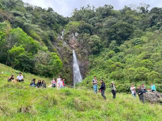
Colombia was ravaged by armed conflict for over 50 years, with the government, guerilla forces and paramilitary groups fighting over land rights and in pursuit of economic and political power. Throughout this time, large parts of Colombia’s Amazon region were viewed as guerilla territory and witnessed fighting, displacement and drug cultivation. For anyone not living there, this was long considered a no-go area – a war zone that nobody would enter voluntarily.
The Indigenous communities who live there were unable to escape the conflict, however. They would often get caught between the sides, with government units or guerilla groups suspecting them of collaborating with their opponents. Many were more or less cut off from the outside world.
A place of Indigenous activism
This was also the case in the villages and communities of the Santa Rosa municipality. Until 2016, when a peace agreement was signed between the government and the FARC (the largest guerrilla group at the time) that did at least bring some semblance of peace, many of the villages were essentially inaccessible for outsiders.
The region is rich in natural resources: Santa Rosa is situated in the Andes-Amazon region in the north-east of the Cauca department, a transition zone between the Andes and the Amazon basin. Mountain ecosystems of the Andes, the remnants of the rainforest and important water-catchment areas boasting huge biodiversity are all to be found here. Yet this natural wealth has been at risk for decades – from state neglect, environmental damage and the conflict.
The entire “Bota Caucana”, as the region is known, is not only badly affected by climate change; it has also seen extensive deforestation, soil erosion, river pollution and declining animal populations. The still smouldering conflict, along with legal and illegal gold mining, have also brought violence, mercury pollution and social division to the local communities. The communities and villagers of Santa Rosa have not let this deter them, however – with the result that Santa Rosa has now become a site of Indigenous resistance.
Land rights are about more than geographical distinction
The Indigenous communities in the Santa Rosa area belong to the Inga People. Dotted around the region, families live on plots of land on which they have their houses, fields and forests. Far than being isolated, however, they maintain a collective form of settlement and live according to the principles of solidarity: they do not regard the land as their individual property but as a place for spiritual and political connection with the community.
For the Inga, the “territory” on which they live means much more than just land and soil – it stands for an abundance of natural resources and a sense of reciprocity, it is the core of their identity and of their roots. Their territory is neither a commodity nor a mere geographical distinction; it is an inclusive place to live, where nature, culture, history and every-day spirituality merge. Traditional medicine continues to thrive here, as do ancestral knowledge, arts and crafts, and Minga, a form of traditional community work. This cultural heritage is handed down from generation to generation.
In Santa Rosa, clean water still flows in the streams and rivers, the air is pure and virtually no pesticides are needed for agriculture. The Inga value their biodiversity and regard it as a gift that entails a responsibility to protect the many species of birds, medicinal plants and wild animals. In view of the threats to their ecosystem and their way of life, however, they – in particular the younger generation – have decided that they have no choice but to become politically active.
A few years ago, they founded the Indigenous “Wairari Atun Sacha” cabildo in the village of Tarabita to campaign for their rights. Their aim is to preserve the social, cultural and ecological heritage of the Bota Caucana.
Young people campaign to protect their Indigenous heritage
Colombian cabildos represent Indigenous communities vis-à-vis local and national governments and are organised as autonomous entities. The cabildo Wairari Atun Sacha represents its community in the Santa Rosa local government. It is part of the association of Indigenous Councils of Santa Rosa and affiliated to the Indigenous Regional Council of Cauca (Consejo Regional Indígena del Cauca, CRIC).
The cabildo’s primary political objective is to have their territory recognised as ancestral lands of the Inga people – as official “Indigenous territory”. Yurani Quinayas, the cabildo’s first representative, explains: “First and foremost, this territory means life. It is our home and a sacred place, an infinite space in which people can develop and grow together.”
The Indigenous representatives of the Wairari Atun Sacha cabildo hope that having their territory recognised will secure their autonomy, as self-governance and collective welfare play a central role in their way of life. The idea is for the people here to be able to decide for themselves how the land, water and forests are used and protected, in line with their ideology. They reject the exploitation by outsiders of natural resources when such projects are imposed upon them, claiming that these give rise to “social and economic disharmony”.
The cabildo calls for state and international conservation funding to be channelled directly to the Indigenous communities that live in the area in question. Its members see protecting the environment as a collective and intergenerational responsibility and therefore ensure that all youngsters are taught about the importance of preserving their natural heritage.
How open-source mapping is helping in the fight for political rights
In 2024, the cabildo joined the international project “Participatory mapping for a sustainable Amazon” (Mapeos participativos para una Amazonía sostenible). The mapping project enables its participants to explain their holistic understanding of territory both to themselves and to the outside world.
With the aid of open-source mapping tools such as the global OpenStreetMap, cabildo members have since been drawing on their traditional knowledge to create maps of their lands. They reveal the region’s biodiversity and multiculturalism and shine a spotlight not only on the environmental destruction that has already happened, but also on future threats posed by illegal mining, deforestation and climate change. The first map includes spiritual and cultural places, such as sacred sites, ancient chagras (traditional agroforestry plots) and trails, communal infrastructure such as houses, pathways and a village school, as well as natural resources such as water sources, streams, forests and different species of bird. Many of these local specificities did not feature on official or commercial maps.
The community calls the mapping tools “instruments of power” because they enable it to document the geographical, cultural, ecological and political characteristics that define their lands from their own perspective. Social scientists support them in creating the maps.
One year on, the members of the cabildo are now administering their own georeferenced information systems. These help them identify risks posed by forest fires or landslides and better adapt to such threats – which is vital in view of climate change. Precipitation patterns are changing, temperatures are rising, and ecosystems are becoming increasingly vulnerable.
Perhaps most importantly, however, the maps provide the Inga in Santa Rosa with political arguments. The charting of pollution and degradation zones on the map has enabled them for example to identify the sites where nearby mining projects have caused mercury contamination to reach critical levels in the catchment area of the Caquetá River. They have also been able to document woodland areas that have been damaged by livestock breeding and the timber industry, as well as remote hamlets that are neither connected by road nor have any basic power or water supply.
The maps make it easier for the community to argue their case and provide concrete proof when dealing with the environmental authorities and other public institutions. Its members can now present georeferenced data to underpin their arguments. The cabildo can also raise the profile of its conservation projects among scientific institutions and environmental organisations.
For the community’s members, the maps they have drawn up together serve as an instrument with which to defend their territory and continue to follow their Indigenous way of life. According to Fernando Quinayas, the “Líder Gobernador” and thus most senior representative of the cabildo: “A cartography project in the Amazon region cannot be regarded as separate from the historic fight of the Indigenous Peoples for self-determination. It is about far more than just mapping: it has given us the chance to build up local knowledge that is deeply rooted in our culture and has to do with love and dignity.”
Sources
Cabildo Indígena Wairari Atun Sacha & Centro de Estudios POMOTE-UNAULA, 2025: Informe de trabajo de campo – Mapeos participativos para una Amazonía sostenible (Visita 12–22 de mayo). Santa Rosa, Cauca. (Informe inédito proporcionado por la comunidad).
Instituto Interamericano para la Investigación del Cambio Global (IAI), 2024: Proyecto „Mapeos participativos para una Amazonía sostenible“ – Bosques Tropicales en las Américas: Enfoques Transdisciplinarios para Transformaciones Ambientales (SG-TF020-2024). Buenos Aires: IAI. (Documento de proyecto).
Leonardo Jiménez García is a consultant in communication for social change processes and a lecturer in communication and social-research methodologies. He is the director of the POMOTE research centre (Centro de Estudios con Poblaciones, Movilizaciones y Territorios, POMOTE) at the Universidad Autónoma Latinoamericana (UNAULA) in Medellín, Colombia.
info@leonardojimenezgarcia.com

